
Perhaps you woke up this morning, refreshed after a night on your memory foam mattress. Maybe you went downstairs and poured yourself a bowl of your favorite muesli – you know, the one with the freeze-dried strawberries? Some of you might have grabbed a handheld vacuum cleaner to suck up the crumbs, or ignored the mess to instead snap a quick selfie on your mobile phone’s camera.
It all sounds like a pretty run-of-the-mill start to the day. But while these miscellaneous items have all become part of our daily lives, they have something else far more extraordinary in common. They were originally designed for use in space.
And as space technology continues to evolve, so too do its applications here on Earth – not only at home, but also in the world of big business. More and more companies are looking to space for the latest technology that can take their organizations to stratospheric levels of success.
An in-depth view
Satellite services are one major area, devised by space scientists, but now broadly harnessed by a large number of companies across the entire spectrum of industries.
Indeed, the European Space Agency (ESA) has been actively promoting the use of satellite services in other parts of the economy for 15 years now, its Head of Applications and Solutions, Nick Appleyard, tells The CEO Magazine.
“Every kind of transport and logistics uses satellites for navigation and connectivity,” he says. “They are used to monitor and manage farming and the ecologies of land and water, they extend critical services like health care, tourism and education into rural communities, they help us to keep an eye on infrastructure on which we critically depend, and they help us to manage complex systems of traffic and resources, even in the heart of our cities.”
“We work with over 100 partner organizations who each have a deep understanding of a market segment where satellites are being used, and together with them we identify innovation and business opportunities.” – Nick Appleyard
ESA started with a few pilot cases and has since worked with companies to integrate this technology into hundreds of new services, ranging from fruit-growing to railway signaling. It has also incubated more than a 1,000 startup companies across every country in Europe with these types of product ideas.
“We work with over 100 partner organizations who each have a deep understanding of a market segment where satellites are being used, and together with them we identify innovation and business opportunities, which we then invite companies to address,” Appleyard expands.
Expert reassurance
Every year, it becomes easier for businesses to benefit from this cutting-edge technology, and although Appleyard admits there is a learning curve and often a high price tag when it comes to integration, he is quick to point out that there are plenty of specialists who can help. The end results often more than compensate any initial outlay.
“Broadly, there are three types of satellite technology: satellite position and navigation capabilities that are now completely standardized into smartphones and handheld devices; satellite communications, which have diversified from the familiar TV broadcast into a range of broadband and data equipment; and satellite images and sensor data,” he says.
“Those familiar images are even available for free, downloadable through the European Commission’s Copernicus data portal, so that’s a great place to start.”
“Mostly we work with SMEs [small to medium enterprises], who can move quickly to develop a new product and demonstrate it with their first customer. We support them with consultancy and technical support from ESA as well as sharing their costs in product development.”
Around half of these projects lead to a commercial sale straight away, enabling companies to raise growth finance and go on to establish a new business. “And if those companies come to us with their own business ideas, we are equally happy to support them in the same way,” he adds.
Mapping minerals
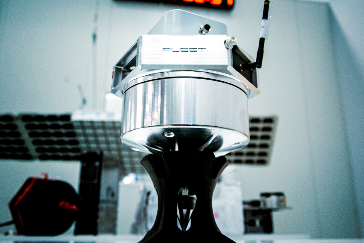
Australia-based Fleet Space Technologies is another player innovating within this field, bringing space technology applications to a broad range of companies.
Co-Founder and CEO Flavia Tata Nardini sees great potential for space-enabled technology in the area of mineral exploration by harnessing this game-changing space-age satellite technology.
“We need to increase the supply of critical minerals by six times in order to achieve our net zero ambitions by 2050, according to the International Energy Agency.” – Flavia Tata Nardini
“We need to increase the supply of critical minerals by six times in order to achieve our net zero ambitions by 2050, according to the International Energy Agency,” she says. “That raises the question of how to make mineral exploration more data-driven, agile and fast in the highly remote, inaccessible regions of the Earth, where exploration often takes place.”
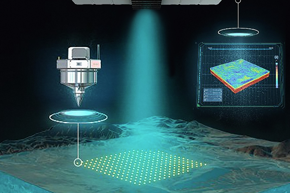
While data acquisition and processing from geophysical surveys has traditionally taken months, space technology that uses constellations of satellites and sensors with built-in edge processing and satellite connectivity, can transmit geophysical exploration data to the cloud in near real-time from anywhere on Earth.
Reduced impact
According to Nardini, while mineral exploration has historically involved large amounts of exploratory drilling, which can be very expensive and environmentally impactful, this space-enabled technology rapidly provides insights that help teams do more with fewer drill holes.
“This is a major step forward in the mineral exploration industry, and we’re proud to contribute our space technology to help make progress toward the renewable energy future our world so desperately needs,” she says.
“That’s why we built our novel, satellite-enabled solution, ExoSphere, to combine the benefits of satellite connectivity with remote geophysical data acquisition to deliver actionable 3D models of the Earth’s subsurface,” she explains.
“Using ExoSphere, we can rapidly deploy an array of seismic sensors to collect data, and return 3D imaging of the subsurface up to 2.5 kilometers in depth in a matter of days, with near-zero environmental impact.”
So far, the ExoSphere technology has been used to conduct more than 180 surveys on a variety of commodity types across five continents. It already has more than 30 global exploration customers, which include Rio Tinto, Barrick Gold and Core Lithium.
Spreading the word
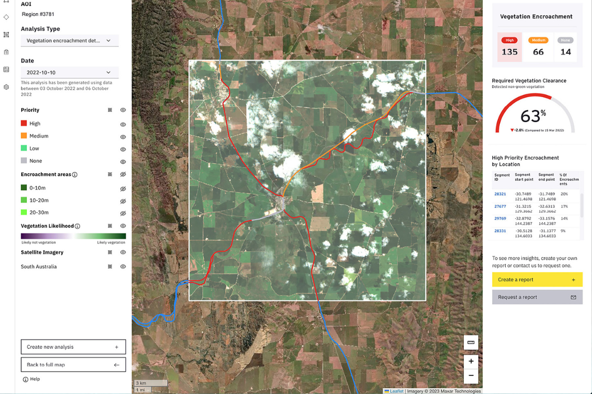
With such intense potential in deploying the genius of space science closer to home, Ernst & Young (EY) has launched its own Space Tech Initiative, which develops client insights for a variety of sectors, under the close supervision of Executive Consultant Brian Killough, a former NASA scientist.
“For most people, it’s a daunting topic that seems far too technical to understand.” – Brian Killough
Some of these include the monitoring of power, utility and railway assets to manage vegetation, detect water anomalies and measure subsidence and erosion; the detection of objects, such as vehicles and solar panels, to support power and utilities as well as governments; measuring carbon sequestration and emissions from land for net zero compliance and carbon trading; and the monitoring of mining assets to track rehabilitation and reforestation progress.
Although the applications are endless, Killough says there is still a lot of work to do to educate clients, businesses and the public about the potential of satellite data.
Finding Solutions
Through its annual EY Open Science Data Challenge, built around the United Nations Sustainability Goals, young professionals and students use machine learning and AI to help solve global issues and share those solutions for societal benefit.
“Each year the challenge has used satellite data to focus on topics such as fire propagation, frog species distribution models in biodiverse regions, rice crop detection and yield forecasting and detection of coastal damage from tropical storms,” Killough says.
EY has therefore launched programs such as EY Ripples and the EY Open Science Data Challenge, which aim to educate the business community on the potential of this sector and how they can harness satellite data to address a number of concerns, such as those around sustainability, ESG reporting and the impact of climate change.
“For most people, it’s a daunting topic that seems far too technical to understand,” Killough acknowledges. “But thanks to advances in computing technology, the development of analysis-ready data products and online learning tools, it is possible for anyone to harness the power of satellite data.”


